The Standard
The accepted measurement criteria in use by the forestry and tree
management industries make use of established methods to
normalize measurement rules and technique thus providing agreeable
results for all parties. Though sometimes inaccurate, field
estimation techniques typically are used in place of other more sophisticated
techniques due to innate variables in measurement such as the
crown spread in different seasons, the slope or rise of the ground
in the measurement area or, more often, variations
due to the "measurer". The standard error for each widely
used measurement technique is fairly similar. For instance,
camparing the stick method of height measurement versus smaller,
handheld clinometers results in very small standard deviations in
the error comparison.
Simple, manual field techniques are as good for
most practical purposes as are the sophisticated methods by providing
equally acceptable results within the limits of error. Texas Tree
Trails opts for the simpler field methods. We also follow
established measurement rules and guidelines set by
American Forests and the
Texas
Forest Service.
Experience has shown that when indirect methods are used to
measure height (as opoosed to the direct methods - climbing, using
height sticks), measurement from two independent positions is
essential (preferentially on a flat grade). The readings from
the two positions should agree within the limits of
experimental/measurement
error. This is an absolute check on instrument and operator
error (sighted to correct tip, etc.). Thus, differences of up to
1 m in readings for a 40 m tree are acceptable - precision of
hand-held instruments under forest conditions is no better than this.
Texas Tree Trails Champion/Big Tree Measurement Criteria 
Tree Index
To measure a tree for possible
inclusion in to the National, State or DFW Big Tree Registries,
three static measurements are required:
The trees "index", or normalized comparison
factor with no units, is obtained by calculating the sum of the
circumference in inches, the height in feet and 1/4 the average crown
spread in feet.
Circumference + Height +1/4 Average Crown Spread = Total Points
or INDEX
Champion trees within five points of one another
are considered co-champions.
Recorded Values
All recorded measurements should be rounded down to the
nearest whole number (i.e. 48.9 feet is recorded as 48 feet, or
132.6 inches is recorded as 132 inches).
Ten-Year Rule
Trees must be re-measured at least every 10 years to maintain
their “champion” status.
What Is A Tree?
 Each specimen nominated for the Texas Big Tree Registry must meet
the following definition: “Trees are woody plants, having one
erect perennial stem or trunk at least three inches in diameter
at breast height (DBH, or 4½ feet), a more or less definitely
formed crown of foliage, and a height of at least 13 feet”
(Little, 1979). For low-forking specimens, this means that one
of the forks must exceed 9½ inches in circumference at 4½ feet
to qualify (see image A).
Each specimen nominated for the Texas Big Tree Registry must meet
the following definition: “Trees are woody plants, having one
erect perennial stem or trunk at least three inches in diameter
at breast height (DBH, or 4½ feet), a more or less definitely
formed crown of foliage, and a height of at least 13 feet”
(Little, 1979). For low-forking specimens, this means that one
of the forks must exceed 9½ inches in circumference at 4½ feet
to qualify (see image A).
One Tree or Two (or More)?
In practice, it must be determined whether a tree has a
single trunk or whether it represents two or more stems growing
very close to one another. Trunks that have clear separation(s) or
included bark at or near the ground line should be considered
separate trees; trunks of different species should also be
considered separate stems, no matter how closely aligned. When
following the circumference rules below, if the point below the
lowest fork places the measurement at the ground line, the stems
should be considered separate.
Circumference
 Circumference
General Rule: Record the smallest trunk circumference between
the DBH point (4.5 feet) and the ground, but below the lowest
fork. Also record the height above the ground, in inches, where
measurement was taken (images B & C).
Determining DBH Point
 Tree on Slope: Measure up 4.5 feet along the axis of
the trunk on high and low sides; DBH point is midway between
these two planes (D).
Tree on Slope: Measure up 4.5 feet along the axis of
the trunk on high and low sides; DBH point is midway between
these two planes (D).
Leaning Tree: Measure 4.5 feet along both the top and
undersides of the trunk; DBH point is midway between these two
planes (E).

Low Branches: When determining where on the trunk to
measure circumference, ignore portions that do not form part of
the tree's crown, such as dead branches or forks, and epicormic
sprouts.
Obstruction at DBH: If there is a bump, burl, branch,
or other obstruction at the DBH point, measure circumference
above and below the obstruction and record the smaller value. A
buttress that forms between trunk and root system as a natural
feature of the species (e.g.—bald cypress, water tupelo) should
not be considered an obstruction.
Tree Height
General Rule: Record the vertical distance between the
ground line and the tallest part of the live crown, in feet. Also
record the method used to determine this value. (Choices include:
direct measurement [telescoping pole, climbing], clinometer,
hypsometer,
relascope,ultrasonic rangefinder [w/ or w/o internal
clinometer], stick method, pencil method, comparison, and wild
guess.)
Leaning Tree: Height is not measured or estimated along
the length of trunk.
Stick Method; Recommended Methods for Beginners:
 There are many tools that
can be used to estimate the height of a tree, but the simplest way
uses little more than a ruler or pencil, good eyesight, and a
friend!
There are many tools that
can be used to estimate the height of a tree, but the simplest way
uses little more than a ruler or pencil, good eyesight, and a
friend!
One person stands near the trunk of the tree and the second
person stands at a distance where both Person 1 and the top of the
tree are visible. Person 2 holds a ruler (or pencil) upright at arms
length and (carefully!) walks forward or backward until the entire
length of their ruler covers the tree from base to top (F)
while holding the ruler at arms length, Person 2 turns their wrist right
or left so that the ruler is now horizontal, with one end sighting
the base of the tree. Now Person 2 instructs Person 1 to move away
from the trunk in the direction the ruler is pointed (at a 90 degree
angle) until they are standing where the end of the ruler points
(G).  Person 1 is now
standing roughly the same distance from the trunk as the tree is
tall. Use a tape measure to record this distance, in feet.
Person 1 is now
standing roughly the same distance from the trunk as the tree is
tall. Use a tape measure to record this distance, in feet.
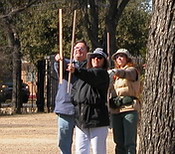
The image below shoes a field technician making a tree height
measurement using the "stick method". Height estimations are based
on the simple geometric formulas of Similar Triangles.
Similar Triangles for the Stick Method,
B = A * b/a
(Where A, a and b and the technician's height are known distances;
A is calculated from the Pythagorean theorem where A = the square
root of [field technician's height + the distance to the tree
base]. )
Pencil Method
There is also
another technique known as the “pencil” method. For this you can use your
pen or pencil, or anything of similar shape and size. In this method it is not
important that the length of the stick above your hand on your
outstretched arm is equal to the
distance from your eye to that same point of the pencil where it is
held in your hand. Simply hold out the pencil and move toward or
away from the tree until the top of the pencil is lined up with
the tree’s highest point and the bottom of the pencil lines up
with the spot directly below that highest point. Then turn
your hand so that the pencil is “laid down” on the ground, keeping
the bottom at the same point. Visually mark the location where
the top of the pencil now is found on the ground out away from the
tree (It helps to have a second person for this purpose). Tree
height should be equivalent to the distance from the pencil bottom
spot to the new pencil top spot as long as that point is at a
right angle to you!
Using a Clinometer
 A clinometer is a relatively simple mechanical device for
measuring height of trees in the field by taking sight
measurements and applying trigonometry to measured angles and
known distances to calculate height.
A clinometer is a relatively simple mechanical device for
measuring height of trees in the field by taking sight
measurements and applying trigonometry to measured angles and
known distances to calculate height.
One technique for specific type of instrument, the Suunto
Clinometer, follows:
- Measure the horizontal distance from the base of a
vertical tree (or the position directly beneath the tree tip
of a leaning tree) to a location where the required point on
the tree (e.g. tree tip) can be seen.
- Sight at the required point on the tree:
- Using one eye: Close one eye and simultaneously look
through the Suunto at the scale and 'beside' the Suunto at the
tree. Judge where the horizontal line on the Suunto scale
would cross the tree.
- Both eyes: With one eye looking at the Suunto scale and the
other looking at the tree, allow the images to appear to be
superimposed on each other and read where the horizontal line
on the Suunto scale crosses the tree. Note: If you suffer from
astigmatism (a common situation where the eyes are not exactly
parallel), use the one eye approach.
- Read from the percent scale and multiply this percentage
by the horizontal distance measured in step one.
- Site to the base of the tree and repeat steps 2 - 3.
- Combine the heights from steps 3 and 4 to determine total
tree height:
- Add the 2 heights together if you looked up to the required
point in step 2 and down to the base of the tree in step 6.
- Subtract the height to the base of the tree from the height
to the required point if you are on sloping ground and had to
look up to both the required point and the base of the tree.
- Check all readings and calculations. Click for a simple
diagram on
How to Use a Clinometer. Courtesy Ben Meadows, 2003
Simple Ratios Method (or fun with
math)
 For
some this may be the easiest method but requires two people - the
measurer and the measuree. Measure the actual height of one person
and record that height in feet and inches (5 feet, 6 inches). The "measuree"
person stands beneath the tree below the highest point.
For
some this may be the easiest method but requires two people - the
measurer and the measuree. Measure the actual height of one person
and record that height in feet and inches (5 feet, 6 inches). The "measuree"
person stands beneath the tree below the highest point.
The "measurerer" holds a yardstick
perpendicularly outward from their body as in the Stick Method,
but sights the "measuree's" full height between two convenient
measurements locations on yardstick, say between 5 and 8 inches.
That would mean the measuree's full body height is equivalent to 3
inches on the yardstick at that distance from the tree.
 The measurer without moving their arm or
yard-stick, carefully walking forward or backward, sights the topmost point of the tree by tilting their
head back and reading the inch marking for the tree top, for
example 27 inches. Write it down. This measurements indicates the
tree is equivalent to 27 minus 5 inches or 22 inches on the
yard stick at the same distance from the tree.
The measurer without moving their arm or
yard-stick, carefully walking forward or backward, sights the topmost point of the tree by tilting their
head back and reading the inch marking for the tree top, for
example 27 inches. Write it down. This measurements indicates the
tree is equivalent to 27 minus 5 inches or 22 inches on the
yard stick at the same distance from the tree.
Using a simple ratio formula we can
calculate the tree height.
Calculating (measuree height/3) is equivalent to
(tree height/22) but we know the measuree height so we will put
that value into the formula (5.5/3)=(x/22). Cross multiply (5.5*22)=(3x) and
solve for x = 40.3 Feet
The formula for a calculating the tree
height is:
(5.5/3)
= (x/22)
or x = 40.3 Feet
DIY
Citizen Forester Method of Tree Height Measurement
As an alternate and simple tool for measuring tree height,
Marilyn Sallee, of the Spring 2006 Citizen Forester Pioneer Class
made a DIY (do-it-yourself) tool out of everyday materials and
offered to share it with everyone.
Great engineering! I particularly like the plumb line which keeps
the tool at right angles; the way it should be so the remaining
angles and measurements can be accurate. Thanks, Marilyn!
The list of materials include:
- 8-1/2" x 11" sheet of heavy paper
- 8-10 inch piece of string
- small weight, bead or button
- fat soda straw
- tape or glue
- pencil or awl to poke two holes in paper
The Instructions, a diagram and details of use are detailed in
Citizen Forester
Tree Height Tool PDF.
Average Crown Spread
Measuring Crown Spread
 General Rule: Along the drip
line of the tree (H), two measurements of the crown width are taken
and recorded (in feet), at right angles to one another. The first is
the widest crown spread (I), which is the greatest distance between
any two points along the drip line. Once the widest spread has been
found, turn the axis of measurement 90 degrees and find the widest
crown spread in this plane (J). The two crown spread measurements
are averaged for use in the tree index formula.
General Rule: Along the drip
line of the tree (H), two measurements of the crown width are taken
and recorded (in feet), at right angles to one another. The first is
the widest crown spread (I), which is the greatest distance between
any two points along the drip line. Once the widest spread has been
found, turn the axis of measurement 90 degrees and find the widest
crown spread in this plane (J). The two crown spread measurements
are averaged for use in the tree index formula.
Drip line: This is the outline on the ground of the
outermost leaves of the crown (H). Only live portions of the crown
are included.
Average Tree Crown = (Major + minor) / 2
Tools and Skills Required
Recommended Tools
| Yard/meter stick (required) |
camera (required) |
| measuring tapes (required, see Forester) |
cell phone (recommended) |
| clipboard/forms (required) |
clinometer (optional), |
| writing utensils (required) |
portable GPS
(recommended) |
Recommended safety equipment: hard hat, work gloves, work
shoes, coveralls.
ID Badge: Contact
Doug Pierson for a Tree Trails Associate
badge with photograph for identification including clear-vue plastic
pouch with shirt pocket/collar clip. He will need a good quality
"head and shoulders" photo emailed to him to add to your badge.
Recommended Skills
Master Naturalist or Master Gardener training is helpful; college
level silvics, botany or similar; comfortable with geometry and
simple algebra; must be able to deal directly with the public, the
citizenry of the Metroplex; able to walk around outdoor areas
in most any terrain measuring trees; willing to take ownership of his or her part in
this project and carry the message to others.
Classroom instruction is offered periodically by local state
foresters and regional certified arborists where basic tree
identification, regional tree knowledge and hands on field
measurement techniques are taught. There is an indoor
instructional lecture with plenty of time for questions and
answers followed by a field trip to a regional park to measure
trees. Volunteer Training sessions are announced in advance on the
Announcements page. Many of
the photographs on this web site were taken at volunteer
training sessions. Registration is required.
 |
 |
| classroom instruction |
field trip, hands on training |
Data Collection
The standard data set to be used is that established by the Texas Forest
Service. An example of the data set can be seen on the
the DFW Champion & Big Tree List as one row beginning with
the tree ID.
Each data record is comprised of data fields that make up the standard data set for each tree detailing it's name, description, unique location
and characteristics.
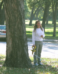
A quality set of photographs must be recorded for the tree being investigated representing color, relative size, shape and any other unique characteristics. A
minimum of one vertical photo with the entire tree in view (important!) plus a series of other
horizontal shots highlighting leaves, fruit, bark, form, unusual characteristics, flowers, structures, damage, roots, trunk, etc. are
needed to complete the data record.
Notes, sketches, botanical observations, observations on the
trees health, evidence of damage, potential hazards, placement in
relation to surroundings (geography), soil, wildlife usage, etc. All are helpful
information.
The format of collection, method of collection and mode of delivery is described in detail in the Texas Tree Trails User
Guide Chapter 2, Data Management. The User Guide in it's entirety
including all information regarding form usage and submission,
Volunteer training, help and the user forms for field
measurements and data submission are available on the
Tree Trails
Documentation page. If you have questions regarding the documentation or forms and their usage, contact
Doug Pierson for assistance.
|
Note: It's a good idea to take one of the Tree
Trails training sessions to get a full understanding of all the
processes involved.
Contact one of the board members to sign up for a training session.
(See the Contacts
page.)
|


